There is a question that every Nepali citizen must answer honestly before debating sovereignty over Lipulekh Pass: if Nepal cannot provide a cardiologist to Narayani Hospital in Birgunj — a city that generates billions in customs revenue — what exactly will Nepal do with 372 square kilometres of uninhabited Himalayan rock?
This is not an anti-national question. It is the only responsible one.
Nepal in June 2026 finds itself in a peculiar position. Its political class waves maps. Its finance minister announces the largest budget in history — Rs. 2.124 trillion. Its prime ministers protest at Shanghai summits. And in the same country, at the same moment, the flattest, most fertile, most revenue-generating province has the lowest HDI of all seven provinces, its central hospital has been “federal” for seven years without a cardiology unit, and 4 million citizens remain stateless.
This is the story of that contradiction.
Part I: The Kingdoms Before Nepal
The districts of Parsa, Bara, Rautahat, Sarlahi, Dhanusha, Mahottari, Siraha, and Saptari — the eight core districts of what is now Madhesh Province — were not empty territory waiting to be discovered by Prithvi Narayan Shah. They were civilisations.
| District | Pre-Gorkha Kingdom | Conquered | Original People |
|---|---|---|---|
| Parsa / Bara | Simraungadh Kingdom (1097 AD) | 1762 AD | Maithili-speaking Madheshi |
| Rautahat / Sarlahi | Makwanpur Sen Kingdom | 1762 AD | Bhojpuri / Maithili communities |
| Dhanusha / Mahottari | Mithila / Videha Kingdom (900 BCE) | Post-1775 | Maithil civilisation — King Janak’s lineage |
| Siraha | Chaudandi Sen Kingdom | Post-1775 | Maithili / mixed Terai communities |
| Saptari | Vijayapur Sen Kingdom | 1774–1785 | Maithili / Bhojpuri — resisted until after Prithvi’s death |
The conquest of Bara and Parsa in 1762 alone cost 400 Makwanpur soldiers their lives. Saptari’s Sen kings resisted so fiercely that Prithvi Narayan Shah died in 1775 with the eastern Terai kingdoms still unconquered. These were military defeats — not democratic unions.
It was conquered into it.”
Part II: The Sugauli Transaction — People as Currency
The Anglo-Nepal War of 1814–1816 did not begin in Madhesh. But Madhesh paid its price. After Nepal’s military defeat, the Treaty of Sugauli was signed on December 2, 1815 — ratified March 4, 1816. Nepal lost one-third of its territory.
The people of Saptari to Bara — the people who are now called Madheshi — were never asked about any of these transactions. They were the land. The land was the currency. The currency changed hands three times in 44 years.
Part III: The HDI Verdict — Numbers That Do Not Lie
Note what the chart above reveals: Madhesh has the lowest HDI at 0.561 — but Sudurpashchim at 0.601 and Karnali at 0.590 are also struggling. This is not a competition. Every neglected province is a national shame. But there is a critical difference: Karnali and Sudurpashchim have mountains. They have altitude. Their underdevelopment has a geographic explanation.
Madhesh has none. Madhesh is flat. Madhesh has rivers, fertile soil, highways, and a border with India. Building a road in Madhesh costs a fraction of what it costs in Karnali. And yet Madhesh has the worst outcomes. That is the definition of deliberate neglect.
Part IV: Budget Per Capita — The Most Damning Graph
Part V: Narayani Hospital — The Seven-Year Lie
Narayani Hospital in Birgunj is the clearest single proof of what policy neglect looks like in human terms.
- Declared federal hospital: February 15, 2019
- Approved bed capacity: 500 beds — Operating: 286 beds
- Sanctioned staff: 321 — Actually working: 234
- Doctors officially posted but working elsewhere: 30
- Cardiology unit: Announced — never launched
- Nephrology unit: Announced — never launched
- August 2024: Hospital announces 47 vacancies
- September 1, 2024 — 4 days later: Ministry verbally suspends all recruitment
- Mentioned in Swarnim Wagle’s FY 2083/84 budget: Zero times
Meanwhile, in the same 2083/84 budget: Bir Hospital in Kathmandu received a burn unit expansion. Kirtipur Hospital received a burn unit expansion. Gangalal Heart Centre in Kathmandu is expanding to 400 beds. Narayani Hospital — serving 3 million people of Parsa, Bara, and Rautahat — does not appear in the budget speech.
And 55 kilometres north of Birgunj, the story repeats. Gajendra Narayan Singh Hospital in Rajbiraj, Saptari: 18 specialist posts sanctioned. One doctor available. HDU shut down due to staff shortage. No surgeon. Patients on emergency ward floors. The medical superintendent absent for over a month — attending meetings in Kathmandu.
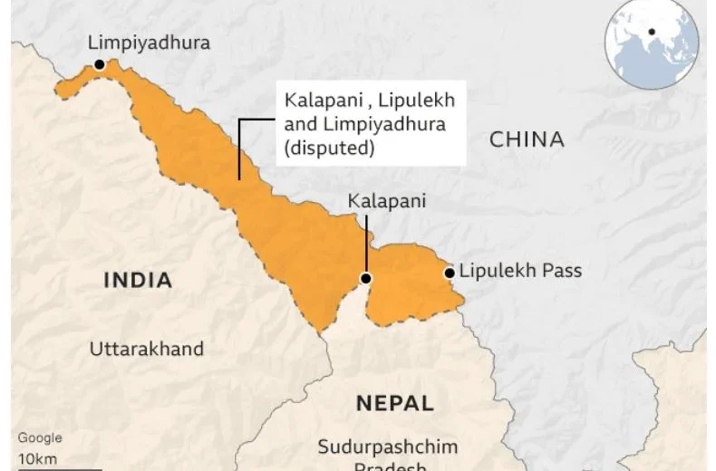
Part VI: Lipulekh — Geography as Politics, People as Pawns
On April 30, 2026, India announced the resumption of the Kailash Mansarovar Yatra via Lipulekh Pass. Nepal’s Ministry of Foreign Affairs issued an immediate protest, reaffirming that Limpiyadhura, Lipulekh, and Kalapani “are integral parts of Nepal” under the 1816 Sugauli Treaty. India rejected the claim as “untenable.”
This is not a new story. Since 1962, when Indian troops established posts at Kalapani after the Sino-Indian War, the territorial dispute has simmered. In 2020, Nepal amended its constitution and official map to incorporate the disputed areas. In 2025, India and China agreed to resume trade through Lipulekh without informing Nepal. In 2026, the cycle continues.
India’s argument: The Kali River originates further east near Kalapani. The route has been used since 1954. India’s administrative presence predates the dispute.
What historical British maps show: Several colonial-era Survey of India maps from the 19th century place the origin at or near Limpiyadhura — supporting Nepal’s position.
Area in dispute: Approximately 372 square kilometres. Population: sparse. Altitude: 3,600–5,500m. Nearest Nepali district: Darchula, Sudurpashchim.
There is a legitimate case to be made for Nepal’s claim at Lipulekh. The Sugauli Treaty language, the colonial maps, the river’s origin — the historical and legal record supports Nepal’s position. But the people living near the dispute — both in the Himalayan areas and in Madhesh — deserve more than geopolitical arguments.
The communities of Darchula and Sudurpashchim near Lipulekh have their own HDI problems. Sudurpashchim has a 34.16% poverty rate — the highest in Nepal. Its people struggle for roads, hospitals, and schools just as Madheshi people do. They are used as proof of Nepal’s human presence in the disputed area. Then left to manage with what little they have.
Part VII: The Geography Argument — Demolished by Data
The most common defence offered for Madhesh’s underdevelopment is geography. “Karnali is remote,” they say. “Sudurpashchim has no roads. Mountains are expensive to develop.”
This argument collapses completely when you look at the data side by side.
| Province | Geography | Road Network | HDI | Per Capita Budget |
|---|---|---|---|---|
| Karnali | Mountains, glaciers, no roads | Difficult | 0.590 | Rs.18,189 |
| Sudurpashchim | Hills and remote valleys | Moderate | 0.601 | Rs.13,121 |
| Madhesh | Flat, fertile plains | 6,002 km — 2nd lowest | 0.561 | Rs.7,701 |
Madhesh is the most geographically convenient province to develop in Nepal. Zero mountains. Zero altitude. Zero passes. Road construction costs a fraction of what it costs in Karnali. And yet — second lowest road network, lowest HDI, second lowest per capita budget.
There is no geographic explanation for this. There is only a political one.
Part VIII: Janaki Temple — Heritage on Paper, Ruin in Practice
Janakpur’s Janaki Mandir — the birthplace of Goddess Sita, standing since ancient times, capital of King Janak’s Videha civilization since 900 BCE — has been on UNESCO’s tentative World Heritage list since 2008. That is 18 years of waiting.
Pashupatinath received full UNESCO status in 1979. Lumbini in 1997. Both in the Kathmandu-hill corridor. A civil society organization named Bhor first raised the Janaki Temple UNESCO campaign through a public signature drive in 2014. The federal government included it in policy only in fiscal year 2024/25 — a full decade after civil society started the push.
The Ramayana Circuit — the major tourism initiative connecting Janakpur to Ayodhya — was designed and funded primarily by the Indian government, not Nepal’s. Nepal’s largest cultural heritage in Madhesh required an Indian initiative to reach international attention.
Solutions: What Must Happen Now
Madhesh has been conquered, traded, silenced, and underfunded.
The people who fed this nation, guarded its southern border,
and paid taxes to three empires deserve one simple thing —
a government that treats them as citizens,
not as geography.”
The Reporter’s Verdict
Nepal cannot credibly demand sovereignty over 372 square kilometres of Himalayan rock while denying a cardiologist to 3 million people in Birgunj. Sovereignty is not just about maps — it is about the hospitals, schools, roads, and dignity that a state provides to its people. By that measure, Nepal has not yet earned full sovereignty over Madhesh. And that is the most important territorial dispute this country must resolve — before any other.
UNDP Nepal / National Statistics Office — HDI Report 2024 · Nepal Living Standard Survey IV (2023) · World Bank Poverty & Equity Brief Nepal 2025 · Nepal Infrastructure Commission Report 2023 · CIJ Nepal Investigation: Narayani Hospital 2026 · Ministry of Finance Nepal — Budget Speech FY 2083/84 (Swarnim Wagle, May 29 2026) · UNFPA Nepal — Maternal Mortality Report 2024 · Treaty of Sugauli (1815–1816), British India Records · Nepal–India Border Documents 1816, 1860 · UNESCO Tentative Heritage List — Janaki Temple (2008) · Nepal News Explainer: Lipulekh Dispute (May 2026) · Nepal Economic Forum — Poverty Trap Analysis 2024 · Madhesh Province Budget 2082/83 (p2.gov.np)

Leave a Reply